
I discovered a very fascinating site--The Atlas of Medieval America. Matthew White created a site that asks what the United States (and surrounding borders) would look like if it relapsed into the dark ages, formed out of the current population, languages and cultures we have today. America is not one single, all-encompassing culture, it is many. However, what's frustrating is, White only really covered a fraction of what could be done. This has tantalized me greatly, especially since there are many maps and links to dead pages. It's evident that he had it mapped out. This pretty much set my imagination aflame, and now I can't help but think about what could have been.
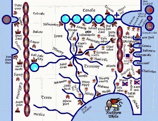
On the front page, when you hold your cursor over the map, there are nineteen clickable locations. This map gives a good number of the flags, though some are "grouped together" under a certain nation or location. Most of these are found on the regional atlases that divide the country. I'm taking stabs at some of these names, mind you, but these seem to be the individual nations; In the Northeast there's New England, New Jersey and the USA. In the "Feudal Core" (sometimes called the Heartland), there's Piedmont, The Deep South, "Tennessy", Ohio, the Great Lakes, Iowa, and something I'm guessing is called "The Southern Frontier". The Gulf has only Louisiana as a nation. The Desert leads to Deseret, California and some kind of iteration of New Mexico. In his vaults, he has Cascadia, which is basically the Northwest area. We have only one flag for "The District of Columbia", which seems to be a feudal, autonomous territory, but clicking on that area simply leads you to "pac-nw" (Pacific Northwest), which seem to be an bunch of independent city states. There's a large cityless area on the great plains that leads you to the nomadic herdsmen in general. There are also two other "orphaned" locations; Quebec and New York (Or possibly "Newyork"). Neither are included in the Northeast or Feudal Core, so I wonder if they have something in common. The St. Lawrence? Being francophone? I fool around with the idea of it being 'The Francosphere".
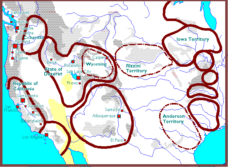
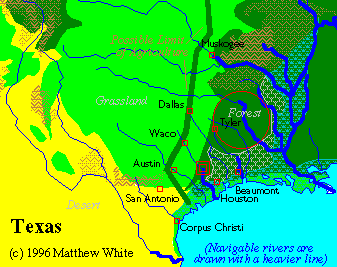
White also has a West Map, to delineate borders, especially for the often fluid tribal west. We see two relatively organized cowboy nations, the Rizzinis and the Andersons. The Andersons, in particular, have taken over a good chunk of Texas, and may even claim the port city of Houston. There's a map of Texas, and towns that may exist in this era. In general, the state has been slightly divided up, which makes sense as geographically Texas is larger than most nations in modern Europe. It looks to have been gobbled a bit at its outermost ends. (Swamp and desert) However, Texas is mentioned as a place on the front page Atlas. It would be interesting to see how Texas as an entity exists.
Major areas of the country have not survived the slide to medievalism, most of them on the western side of the country. This map gives us a good idea of the One is the Denver, Colorado metropolitan area. Denver a major trade stop for the continent, and the crux of "Rocky Mountain culture". According to White's page, the area has dispersed to the nomads. Apparently Salt Lake City has become the new gateway to the west, and perhaps it makes sense that a rigid papacy would do a better job of holding a medieval society together in the harsh mountains than one which counts on energy sources. . Also, there's Florida. In the modern age, it's a very populated state and the site of major cities. However, White has penalized it for being mostly swamp. I still think it would survive as a major port hub between the islands and the mainland, but the world White provided says it's generally dissapated.
Throughout this blog, I'm going to explore the areas unmentioned. Those little icons and dead urls that are just waiting to be explored. I don't think White's going to come back anytime soon, but if he has a problem with this, I'll take it down. But in the meantime, I have to share what's been spinning in my brain. I hope to create discussion here as well.
Very interesting. I know you've already told me a lot of these theories, and I still find them fascinating. Are you going to put maps here? You could recreate the originals or put them here and cite the original website.
ReplyDeleteI passed the link on to Cassie, by the way, she's bookmarked it.
I do plan on linking his maps, as well as the maps I've made that compare political/religous zones to the existing state borders.
ReplyDeleteCould Columbia be some kind of "Knights of Columbia"?
ReplyDeleteA knightly order, created to protect a remaining chritian enclave at the Columbia river.
Hmm, an interesting idea, but the maps I've seen clearly present it as under Buddhist territory. Remember, much of the Northwest simply was not religous up until now.
ReplyDelete