Monday, December 1, 2014

Cultural Clusters


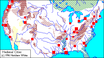
If you'll notice, the eight biggest cities tend to have another smaller city reasonably close by. It was then I noticed on the Eastern map there quite a few locations where cities will be less than one hundred miles of the next one, until the pattern eventually dies out. Usually that restriction is set apart by natural barriers like mountains, but that's not always the case.

I decided to take a look at the larger maps and see which areas had at least three cities (in excess of 25,000) that were no more than 100 miles at a time. Actually, something that occurred to me was that cars were no longer a factor in this world, so driving miles wouldn't count. However, straight distance wouldn't quite tell the tale either. I basically averaged between the two to get an idea. For the most part, I didn't get any real conflict. An odd quirk though, is Grand Rapid, Michigan, which is a considerable land distance from both Chicago and Milwaukee, but much shorter when making most of the trip by water.

Perhaps the biggest chain is the found where it's found today--the Northeast Atlantic Seaboard, containing nine or so cities that so cities that are never more than 100 miles apart. Starting around Boston, it ends around either Washington DC, or depending on how you look at it, Richmond. (That is, if you count Providence and New Haven by straight distance. It would still be seven cities in the chain) The top four shortest distances between cities are found here, and even removing Providence/Boston, (the closest distance between two capitols/District Headquarters) you still find it in the top three. Of course, it's largely stretched out, as the route is some 400 miles long, but never far from the coast, with only the Delaware River cities being inland. As a result, there's definitely room for a wide racial and cultural spectrum between Boston and Washington. However, the trade network of the U.S. Mariners and close proximity of District Supervisors probably helps keep a continuity.

Next is the Mississippi basin, contains seven cities in the chain. It starts at New Orleans, and ends in Shreveport, which are both in present day Louisiana, but curiously, it requires Mississippi-based to keep the under-one hundred-streak going. The is actually rather impressive, considering how much of the area is not conductive to producing larger population densities. This is likely the result of the importance of New Orleans as a trading port and naval power, and it might be no coincidence the lower Mississippi was the base for some of the most advanced Pre-Columbian civilizations. The plurality of these cities are in Red River territory, and note that New Orleans largely practices Voodoo, so this may be the most mixed-faith culture cluster on the continent.

After that we have the Ohio River Valley, which has only four cities that are within a 100 mile chain, but two of them are some of the largest on the continent. These cities are found in present day Ohio and Kentucky, which today make up a single kingdom. There are three other cities in Ohio's borders, one Terre Haute, which is probably a frontier/defense town, (Like medieval York) and Toledo, who's closest city is rather close Detroit. These border cities may or may not feel a shared cultural heritage as the Ohio Valley triangle.

As for the rest of the Eastern U.S., the biggest cluster is around Lakes Ontario and Eerie, with three cities--Buffalo, Toronto, and Rochester. Buffalo is the only major city, but the area is rather special for being cross-coastal, and also containing a piece of Canada. The waterways probably keep it very tight, but the very cold winters keep it from becoming too large.

Then we head to the Western half the country. Its population is much smaller, and much more spread out, as there's less arable farmland, and most of this was filled in by a more modern, automobile-based world. Still, there are some smaller concentrations.

There's California, with the three cities of Sacramento, San Francisco and Stockton. It's something of a mirror of Ohio, with a very concentrated triangle as none of the three cities are more than a hundred miles from each three cities.  Fresno manages to be a bit outside that range, although it's mostly accessible by river. Bakersfield and and especially Los Angles are much farther apart.

Finally, we come to the Northwest cluster, or rather clusters, as Porland and Tacoma are pretty far away from each other, and separated by mountains. The "Oregon" half has bigger cities, but the Washington part has more, including two Canadian cities, Victoria, and Vancouver, basically showing how in the new world order of Medieval America, former arbitrary borders don't matter.

Tuesday, April 1, 2014

Comparing States

I thought I'd do a comparison of to the population today's states, withe the population of those given areas in the Medieval America world. Now, the whole continent has plummeted by roughly four fifths, or 80% or so, however this is not an across-the board number. Some places have seen their populations plunge even deeper, while others have been relatively more relaxed in their decreases. (By comparison, Canada has decreased by 88 percent.) Figures for states largely inhabited by nomads are a little more difficult to pin down as, by definition, those populations will always be in flux. The Dakotas, Montana, Kansas and Nebraska are almost completely occupied by Herdsmen, so it would be hard to be fully accurate. (And then you have Nevada and Colorado, which flirt with being uninhabited) I've put asterisks next to states who have a mixed population of settled farmers and herdsmen. So what causes some of the once mighty states like Texas and California to fall so hard?

Extreme Climates:

Probably the easiest to pick up on, there are places in America there are just not as hospitable without the heat or water, meaning populations of former urban hubs like the Twin Cities or Phoenix were scattered to the winds. But even places like Florida and Texas can be unbearable--much of the southern population boom of the latter half of the 20th century was due to the invention of air conditioning. Obviously, there's not a lot of mobility, so much of the deep south isn't going to completely dissipate, but there aren't going to be as many major metropolises--your Houston, your Phoenix, your Miamis, etc. Likewise, the states like New England or Minnesota have trouble feeding peoples. The Northeast's access to the sea and history of infrastructure keeps it from plummeting too much, but it's not mecca it once was.


Decreased Urbanization:

Obviously, a less industrial society means a smaller population, but it also means smaller cities, and in turn, cities being a less significant portion of the population. Farmers make up to 90% of the population in medieval times. Cities in the modern period are able to defy natural limitations--make buildings taller, ferry garbage away, import resources. With this, we've seen a  steep decline in much of the smaller (and first to industrialize) states of the the northeast, versus the larger states, rural of the deep south. New York City today has a population of 8 million--more than any former state, and most medieval kingdoms! If you remove New York City's population from that of the state, the decline goes from 84% to 72%. The former borders of New York still contain a healthy 3 million (the most outside the Ohio Valley) but there are simple geographic limitations. With a medieval level of technology, there's a much lower ceiling on how many people can live in a given space. With less emphasis on metropolises, states are now confined to the limits of 100 or so denizens per square mile. Compare New Jersey, which saw a heavy 90% decline, with Mississippi, which has the lowest. New Jersey, in the modern day, is the U.S.'s most densely populated state, absorbing much of New York and Philadelphia's metropolitan areas. Even in Medieval America the area that was once New Jersey is very densely populated, but it is very small--smaller than some New England states. Mississippi saw the most level decline, because it's very large, and already pretty rural--none of its cities are among the 100 largest in the country.


"Frontier Effect":

As you can see, I haven't even bothered to include much of the prairie states. One reason is that as the grasslands are now inhabited by nomads, even gauging the exact population is a futile effort. White estimates there are some three million herdsmen on the grassland. (With another million or so in the desert) With seven states that have completely turned to pastoralism, (and Wyoming all, but), we have 375,000 per state on average--probably less considering that doesn't include Texas and Canada. Not a huge loss for the Dakotas, Montana, or Wyoming (Which, during a busy enough season, may see occupation that rivals it present day population), but a heavy hit for the two farm states of Nebraska and Kansas, and especially Colorado, who set itself as the epicenter of the Rocky Mountains. Obviously, the biggest cause of deprecation out here is the oft-mentioned hordes of Cowboys, who won't let farms or cities dot their territories. However, it should also be noted that with less coasts or navigable rivers, transportation is much slower and potential immigration and trade networks aren't able to form the confluence that makes up cities. Likewise, with no oil industry or heavy mining reduces the importance such places had in the Industrial age. Ultimately, civilization peters out until we get to Salt Lake City and the rivers of the Southwest.

*Arizona: 96%
Florida 95%
*Texas 95%
California 94%
*Utah 93%
*Minnesota: 92%
California: 92%
Rhode Island 92%
Texas: 92-88%
New Jersey: 90%
Connecticut 90%
Massachusetts 90%
*Oklahoma 89%
*New Mexico: 85%
New York: 84%
Washington: 83%
Vermont: 80%
Maryland: 80%
*Wyoming: 80%
Pennsylvania: 78%
New Hampshire: 75%
Virginia: 75%
Georgia: 75%
Oregon: 75%
North Carolina: 74%
Iowa: 73%
Illinois:72%
Michigan: 71%
Idaho: 68%
South Carolina: 67%
Tennessee: 66%
Wisconsin: 66%
West Virginia: 65%
Louisiana: 65%
Ohio: 63%
Missouri 62%
Indiana 58%
Kentucky: 37%
Arkansas: 37%
Alabama: 37%
Maine 24%
Mississippi: 13%