Sunday, June 28, 2009

The Feudal Core


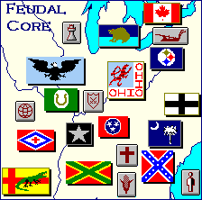
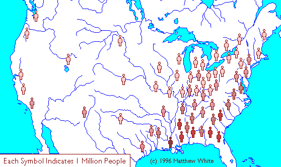
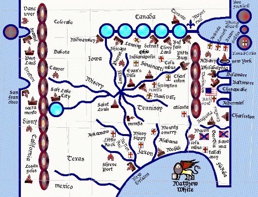
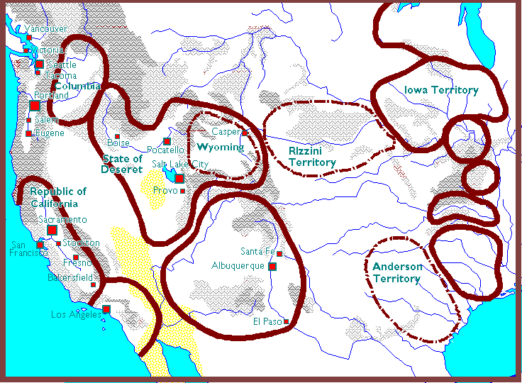
The Feudal Core is an interesting region of the map. Unlike many of the other sections, this isn't necessarily categorized by geography, so much as the social structure (Although it's also called "The Heartland" in many files". Pretty much all the nations in this area are governed in a feudal society, with 14 of the twenty major feudal kingdoms. It's also, in many ways, the core of America in general. It's mostly eastward, but moving somewhat towards the middle, and as many as 28 million (nearly half the population) live there. This is no longer flyover country, but where most of the action is.

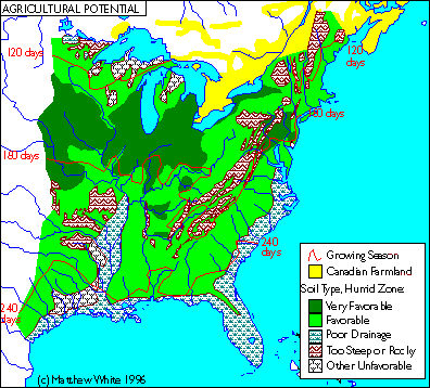
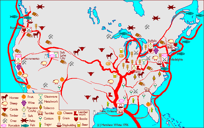
White has touched very little on what it's like here. Most of what we know about the Feudal Core is what contrasts it, like the Horse Archers. We do know what their religion is like, as they, like the United States of America, are strict practitioners of Non-Denominationalism . We know almost a third of them are distinctly part of the Southern culture. Everything else is pure conjecture. From the trade map, we can see it's very much agrarian, gradually going from cotton, to tobacco, to grain in the northern regions. And we know that the, along with its feudal overlords, it tends to favor knights, except for some of the newly conquered frontiers and sparsely-populated mountains. What we do know about the feudal states in America is that a great many of them share names of rivers, and that the leaders, despite being feudal warlords, don't want to take the outright monarch terms like "King" or "Prince" but take on titles like "President", "Governor" and "Colonel".

Iowa is the only feudal core nation mentioned, and perhaps betraying White's fascination with the herdsmen, and seems to have a pretty distinct parallel--barbarian tribes that eventually went native, like the Saxons, Vikings, and Magyars.

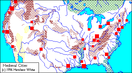
Ohio seems to have absorbed Indiana and Kentucky, and may be the central power of the Heartland, perhaps even the entire continent. Inside its borders you have three important trade cities, six, maybe even seven million residents, and as many as four district headquarters for the Church. The Iowa page shows that it did a decent job of defending itself from barbarian invasion. The Ohio river allows it to be a major pathway of commerce (and the occasional river barges), and the vast amounts of grain it produces means massive amounts of armies. What likely keeps it from becoming completely dominant is that it's still a little landlocked.

Below Ohio is the much less stable area of Tennessee. This is may be the most balkanized region of the continent, and "Balkan" may be the operative word here. The state's "three grand divisions" have been accentuated, between the hot cotton country of the west, the "capital district" (and thus, possible ecclesiastical fiefdom) of the middle, the Appalachian, possibly highlander-inspired West.  However, the most western flag is a green flag with a horseshoe mark This may be Missouri as Iowa's page seems to say Shelby had a hand in rebuilding St Louis, so the area as a whole may generally be considered a colony of patronage of Tennessee, hence its classification in the area.

Piedmont is an interesting case study. It appears to be the only area in the core to have access, to the Atlantic although the US's presence, and very swampy east coast has kept them from building there too much, and they pretty much stick to the fertile valleys. During the Revolutionary War, it was the epicenter of Loyalists. In the Industrial Age, it was the model of the New South, and a growing source of votes for the Democratic Party. In Medieval America, it's very physically close the mercantile Republics. One can imagine a very courtly, cosmopolitan atmosphere. In fact, the warfare map shows it's not a war zone at all. Thus, Piedmont is probably the most picturesque, almost Fairy Tale-like place on the whole continent.

The Deep South comes next. it's symbolized by two flags, both with crosses. One is Georgia's flag, and more or less the symbol for the Confederate States, and Southern Pride in general. Though the url says "Dixie", the Southern lifestyle page is called "Deep South" on the front page, and thus everything White talks about is most exemplified in this section, and this might have been the last "nation" page to have been written, if ever. The area includes Georgia, Alabama and Mississippi, more or less, forged into two large nations and a smattering of smaller ones. I would guess nobody cheered louder when civilization fell, as the South was finally able to call their own shots and draw on their own history. With its warrior culture, scantily clad population, and plantation manors made out of marble, we're probably looking at an aesthetic not unlike the movie 300, but with more confederate flags. Which for many fans, may be the only way one can improve the movie 300.

Finally there's the Southern Frontier. Or it may simply be the Southern Front. The two flags we see is Arkansas's flag with a cross, and another is the flag of St. Magnus, with an alligator on top of it. This leads me to believe that we're dealing with buffer/crusader states, that are bulwarks of of a cultural triangle between Non-Denominationalism, New Israel, and Voodoo. The alligator flag belongs to Red River, which seems to be a hodgepodge of Arkansas, Texas and Louisiana. Note that it's the largest kingdom without a District HQ in it, which probably truly means it's considered a frontier, and may be a real mix of different cultures, much like the Levant in the old Middle Ages.

Saturday, June 27, 2009

The Northeast


We'll start our exploration of Medieval America here. This is the site of some of the earliest settlements by Europeans, and nine of the original 13 colonies. It was where two of the four largest cities of the country were, and the source of a thick urban corridor which defined modern America. So we have both a model of pre-Industrialization, and post-Industrialization, to really get a good idea on how much this world has changed. 

The Northeast is still probably the most urbanized region in North America, despite its status being greatly  diminished. This is probably because of continuity--many of the oldest municipalities, were designed for a population before automobiles, and organizations would have precedence for a de-industrialized way of life. The bays and islands also help a great deal in maintaining a maritime culture, which are also historically more city-based.

We have an icon of a plow that leads to "Yankees". This would be the lifestyle for those who dwell in the north, but what does that indicate? Looking at  Southern Farmers, this would largely mean Americans who live in the green, under six month area (not including the areas that are colder due to higher elevations). When you look at this map , a lot of the most arable soil tends to fall in the that line. So a people that can be well fed, but they have to work hard to for it, and probably reserve most of their downtime for the winter. Funny enough, White makes no mention of potatoes. It's possible he neglected them, or even planned a potato blight because 1) He wanted Northerners to strictly eat Old World foods, or 2) He considered the potatoes to be a bit of a game breaker. White didn't have an image of the Yankees in his cachet like he did for Southerners and Herdsmen, but that's probably because they dress pretty similarly to Medieval Europeans. The Northeast isn't lousy with natural resources, so they focus on crafting finished goods.

However, the "Yankee" Notheast culture isn't completely defined by the climate. After all, this include Maryland, which is below the Mason Dixon line, and even New Jersey can be pretty warm.
That's because something that defines The Northeast, that separates it from the Feudal Core, is the sense of Republicanism. The U.S. remains a republic, probably more out of inertia/want for retaining power, but a republic it remains nonetheless. Maryland also has two other aspects that makes it part of the overarching Northeast culture, despite having more in common with the tidewater south. The first that, as it's basically split by the Chesapeake Bay, it's developed a nautical culture that's very distinct from the warlords out west. (Though they do appear to have knights). The second is that it's home of the headquarters of the Non-Denominational Church, and as former state capitals tend to serve as district headquarters, and Northeast states are small, and their capitals fairly close to each other, this means the Church has more of a say that military strongmen. What effect does this have in the region?

If you combine a mentality that is shaped by Puritans, Quakers, and Dutch merchants, it means a society that is somewhat ascetic, but charitable and not focused on class differences.  It should be said that that more church HQ's and a bookmaking industry might turn the Northeast into the new Bible Belt. It's not that the Northeast is necessarily more religious, it's just there are more physical bibles per capita.

White has already covered what has happened to the federal remains of United States. I won't get into too much, but it look two cities it's definitely taken over are New York and New Haven. It's also absorbed the bays of Rhode Island and Massachusetts, but it's unsure how much.

New England has broken down a little bit, with ten or so states where once there was six. The borders seem to gravitate towards a more circular shape when possible, and similarity in size, as opposed to the rectangular states of old New England. They conduct their government as republics, not as expansive sea-faring empires, but likely as collections of towns and villages with town councils dating back to colonial times. There's a lot of Church supervisors, but no major cities, except for Boston and Providence. Both are located in Massachusetts, which is the big dog of New England, and is the only country with its own map. Well, they may be located in Massachusetts--they border the territory of the U.S. As this map may hint at, there's something of a fight going on in this area, and maybe those two cities are constantly fought over. Or maybe Massachusetts is a client state of the U.S., and it operates like a colony, much as it did when it was first founded. In general, New England operates as pure, distilled, Yankee culture.

And then we have New Jersey. It includes the historical state borders, but also extends into Philadelphia. As this trade map shows it's possibly the breadbasket for much of the Northeast territories, and being more agrarian than its  neighbors may be why it's a feudal state. I also have a theory that a few Mafiaos have taken over at some point, and the Mafia has always had something resembling a feudal order. Still, it's probably more mercantile than the kingdoms in the Heartland, and curiously, it looks like they prefer to use pikes to cavalry, which is a bit of an outlier. The rule of thumb is that pikemen are more popular in Republics, (though it also seems to be popular in the Appalachians for easy to see reasons) and knights in the feudal territories. It's possible that while much of the Northeast fancies itself the heir to the Classical World, New Jersey is the region's answer to Sparta or Macedon.

Thursday, June 25, 2009

Religion

The last of the three color coded maps is religion. This is by far the most diverse of the maps, with eight different kinds of regions, and three icons for likely various miscellaneous categories. To be honest, this is probably where White lets his imagination run away him the most. On some level, it's hard to imagine Scientology and Buddhism overpowering the regions, which do have primarily Christian populaces. Perhaps the history of how these religions came to power would have explained that, and have been pretty fascinating. When you think about, religion can take some amazing turns in just a century or two.


The majority of these religions are Christian-influenced. What I noticed, looking through the image archives, is that White had more of the borders that dot the pages. Not a hard and fast connection, but it seems to me that many of the borders correlate with a religion, and different pages that fall under that denomination, which might explain why some of them were done late, as White may have been deciding which border to associate which pages with.

Most of the country worships via the Non-Denominational Church. At least half, taking a guess. It's, rather ironically, that last vestige the United States that exists throughout the country. The last flicker of federalism. Any relation to the Roman Empire is probably very much intentional. It has a much greater presence in the North, and there might be a lot of grinning and bearing in the South.

Covering a large tract of land are the New Israelites. The popular religion among the cowboy tribes, the name may let people forget that it's still a very Christian religion. It's in fact, and old school one, that may have been quite popular with fundamentalists and evangelicals.

Along the Gulf coast, we see Voodoo taking hold. The real Voodoo is historically a mix between Catholicism and many African religions. Practiced mainly on the island, the Haitan immigrants to New Orleans and Southern Florida is not quite as prominent, but a few hundred years could fan that flame. It should also be said there's no guarantee the zones for each religion are homogeneous, and Voodoo may even be just be a sizable but peculiar minority. A lot of women have been prominent in the history of Voodoo, and it is practiced in the Secretarial States. Throughout the world, there's been a bit of a fear over the religious leaders supplanting the secular ones. This could easily be amended in countries where the Queen serves as the High Priestess. To make sure that ambition and politics don't play too large a role in it (Say, a nubile young dancer coming onto the King), potential Priest Queens are selected at birth, and groomed for her dual title. Or perhaps Voodoo queens are to be celibate just like the Justices.

Further West we have Mormonism, the last of the religions theoretically tied to Christianity. The members of the Church of Latter Day Saints finally has what they wanted--isolation from the outside world, and a nation to do as they see fit. Missions have been long part of the Church's history, but it's probably not see easy in this era. Chances are spreading the message and seeking to convert has become more dangerous-and in turn much more violent. As the armies are usually at the fringes of the world, the job of being Missionaries usually falls to them.

It's hard to denote what exactly "New Age" is. It's not any organized religion by any stretch of the imagination, and you probably couldn't get two people in the same commune to agree. It certainly seems like an odd pairing with the rigid structure of a Hydraulic Empire. If I had to guess, it involves a mixture of Navajo, Hopi and Egyptian beliefs, with a strong emphasis on the environment, and morphed into centuries of rituals and dogma. Note that the former state of Colorado is a triangle of Mormonism, New Israelite and New Age.

Taking over California is Scientology, the controversial cult that I won't get into too much in fear of having this blog sued, but it's curious this managed to explode so much. In some ways it feels like a parody of California culture by having a Hollywood cult control the entire state. There is one thing to keep in mind though, is that the small empire that dominates the south is called "The Free Zone", which is the branch of Scientology that has rejected the "pay as you go elements". Whether that sect has taken over or been co-opted by the religion is anyone's guess. It seems almost strange that a faith with so many sci-fi trappings could fit in the modern world. But hey, lasers become magic, aliens become demons. However, the star-based backdrop probably makes astronomy very, very important to the faith. Just like the Egyptian Kings are the descendants of Gods, so do the rulers of California descend from the stars, and return there upon their death. I also wonder if the rich tapestry of the motion picture world itself has become part of the backdrop, with Marilyn Monroe, John Wayne, Darth Vader and many others become Gods, Heroes and Monsters of Scientology mythology.

The Buddhists have taken over the Northwest. Now, Washington and Oregon do have a sizable Asian minority, (and influence), and they're among the least churchgoing regions in the country, but I do wonder if this is enough to fan the flames into a movement. And they almost seem a little too belligerent to take the teachings of Buddha to heart. So I wonder if this is something that has transformed more than even Christianity under the Non-Denominational church. Also, as I mentioned above, I pointed out New Age beliefs have as much a foothold in that region as they do in the southwest, so I theorize American Buddhism maybe be warped have a lot in common with New Age--particularly the sacrosanct nature of the environment. High priests revere and consecrate the trees and brooks. To rupture nature is to disrupt the balance. While the a lot of the nation may not be fanatic about it, out here pollution and waste may be as big an offense as eating pork on the plains. If not much moreso. Therefore, Buddhisms consider it their duty to preserve nature, no matter what. People are a different matter entirely...

And finally, we have Catholicism. White mentions much of Europe has returned to it, and the Vatican may serve the same role it did in the Dark Ages, and the Non-Denominational Church does in America. There' probably not much to write here. While I've said that a lot about a faith can change in a thousand years, I think when the religion is already 1500 years old, there's probably not much more to tinker around with. Originally a minority in the United States, they eventually grew to become the largest denomination. During the rise of the Non-Denominational Church, it's very likely a few were driven off to Quebec or Mexico, or underground, but there may be Catholic ghettos, similar to the Jews.

Judaism apparently has its own page, and even its own design border. Jews' survival instincts would allow them to weather the downfall of humanity, and the map of Richmond indicates Jewish neighborhoods area staple of cities, at least on the Atlantic Seaboard, especially the Mid-Atlantic, with its relatively Jewish population. There's also a likely sizable pockets in St Louis, which was recently rebuilt by merchants, Florida, as it's sort of a mixed religious area anyways, and a tribe in the Mojave Desert.

Wednesday, June 24, 2009

Warfare

The second map White shows us is Warfare. The map seems to indicate only four fighting styles, although there's probably several different ways to kill someone in this era, these four styles maybe be the largest on a mass scale, and most peculiar to their "zones".


At first glance, one is tempted to just correspond armies with government types. For the most part it can looks that way, but it's but there are cases where certain soldiers serve outside their usual polity match-ups.

The Horse Archers are the only units the site goes into detail on. They start to appear in the more Western parts of the continent, and their range is by far the largest, as they're natural combatants of both the grasslands and the deserts. However, the population density for the nomadic communities is low, but still, since horse archers make up a quarter of the population, that's still two million or so on the plains. No wonder they're so feared, and it's hard to settle a community past the Mississippi. One thing that I've been wondering about is how it seems to be the primary form of warfare throughout the desert kingdoms of Free Zone California and New Mexico, and it's likely they're more akin to the light cavalry found in ancient Persia than the more steppe-barbarian Cowboys.

In yellow, we see an icon with a line of men holding polearms. The page is labeled "Pikemen". Pikes and spears were very popular in republics and early democracies like Rome, Medieval Italy and Greece. This form of weaponry could be especially useful with a large, relatively untrained force, and is one of the best counter measures against cavalry. They seem most prominent in the Republican city states, which makes sense for urban populations with a premium on space and a large middle class populace. It's hard to tell how many are found on the continent,  as it's quite possible pikemen are found wherever there's a large urban population that can support a standing army. It's also of note that it's not just the city states, but New Jersey (a feudal kingdom) and the Appalachian mountains. Pikes in rugged, mountainous areas are not unheard of-- take the Flemings of Medieval Scotland. As for Jersey, it might just be a case of "when in Rome".

The green patch with the shield signifies "lancers', the heavy cavalry fighters. In short, knights. White even has an image on what they would look like. The apex of the feudal warrior class, they're associated with feudal states, although there are quite a few in the desert as well. Historically, a knight has to be rather wealthy to afford the horse and equipment, but in the Hydraulic Empires, the rulers are able to allocate their considerable resources to knights who report directly to them. Interestingly, the knights of Deseret are also celibate, so that would make them very comparable to the Knights Templar, or possibly paladins of role playing games. I wouldn't be surprised to see that specific branch called something like Templars (Mormon worship is conducted in temples) or Crusaders. (The lancers seen in California are also supposed to be celibate, but I have a theory the fluctuating politics and richer forests of that region makes more "in theory". The dynastic turnovers White mentions are probably more common there.) However, there's also lancers in the area that occupies the New United States, particularly the area that occupies to Chesapeake Bay. For now, I'm drawing a blank on why it's there. For the first few centuries, many automobiles were scavenged and melted down to make weapons with. This has often made things like Mercury, sables and thunderbirds part of the heraldry.

There are many white spots on the map. Perhaps no war is waged at all, but I have to say I do have doubts about that. There is likely still a population that clings to the upper north, and the harsh winters have made them mean. Also, the Great Lakes region provides a quick and easy transport from the areas that probably cannot provide a lot, to those...that can. Thus, I would bet Minnesota and Northwest Ontario are home to Raiders, who routinely plunder the kingdoms to the south, and return home. Those of a kinder disposition might be tempted to trade metals and furs, but for the most part we see a powerful group of Raiders, with clubs and axes that do quick sacks and runs. The Lakes are somewhat easier to navigate, but also provide less buoyancy, so the raids are designed for frequency.

Florida also seems to have little military,even though Secretarial States were formed out of practical military matters, so there would have to be some kind of warrior class. My belief is, like the Horse Archers their combat come heavily from their way of life, and like Pikemen, their weapons are lightweight and no heavy on resources. Therefore, I think many of what they use is also good for the jungle. Bolo whips, poison-tipped darts and scimitars for cutting through heavy brush. Also, it's pretty certain that just like centuries ago, these islands became dens of piracy. I also have a theory that the reduced population might have to do with many zoo and circus animals making themselves at home. If the residents played their cards right, they might be able to have something akin to war elephants seen in India...at the very least I can see that tactic forming in Latin America.

Finally, while open warfare is not conducted in these regions, I think there is an occasional bout of espionage. this is especially true in the Cascades. These regions are probably occupied by rangers or certain kinds of spies.

Tuesday, June 23, 2009

Government

Of the many maps Matthew White drew up, three share a certain similarity; They divide up the country into different colorized zones. There's one for government, one for warfare, and one for religion. The first we'll be looking at is government. What I've done is take these maps, and placed them over North American borders. It's not perfect, but it gives you a very good idea on what goes where.


The different zones, if you look closely, have a circular radius that moves ever outward. I don't know if that indicates the centers are more populous, or are some kind of core, but it is noteworthy that Ohio is a principle kingdom.

White's already explained two forms of government to us. The first is the Secretarial State. (As seen in yellow, with a quill for a symbol) Covering Caribean islands, Florida and coastal Louisiana, it's one that White himself made up, from what I've researched, but to sum it up, it's a government where women take care of civic duties on behalf of their hard-traveling husbands. It's uncertain if this resembles the mercantile or feudal governments otherwise, but it's probably a bit of a mix. The poor drainage and coastal locations suggest trading is a big part of these areas, but may be monarchistic than oligarchical.

The other system of government White talks about is Hydraulic Empires. Colored gold, we have California, Deseret (Salt Lake City and surroundings), and New Mexico. Situated in the desert, they are absolute monarchies with an efficient and omnipresent government. White makes comparisons to ancient Egypt, though America's arid lands more resemble Persia.

The next three forms of government are not described, but we have much more decent reference points. In the red circles are the Feudal zones. It's the type of government we most associate with medieval times, and it would appear most of the people on the continent live like this. Feudalism, in theory, is where warriors divide up land up amongst lower and lower tiers until you have farmers that work the land. Warfare and agriculture essentially make up this system, so it tends to take place in areas with the best farmland or mineral wealth. Listing every feudal nation would take a while, so let's just say it consists of most of Dixie, the rust belt, Quebec, and strangely enough a patch of inland west of the Rockies. From what I've gathered, most don't call themselves "King", but use titles are in-name-only relics of a democratic past.

Next are the republics. Colored blue, they're pretty much New England (give or take Vermont), the Capital Beltway, and the more populated areas of the Pacific Northwest. They largely take a cue from Medieval Italy, which were independent city states (and occasional empires), which thrived largely on sea access. Of note is these areas had very dense populations in modern times, and the very "blue state" gravitation towards infrastructure may be reflected here, as well as the locations of prestigious universities.

The area shown in green with the hand as a symbol has primarily tribal societies. It encompasses Mexico to Canada, with its core being the Great Plains. The most talked about tribes are the cowboy ones, with a few reference to desert shepherds, like we see in the Middle East the "tribal" swath is quite large. This map shows that further north, way into Canada, we see references to "Hunters". These might resemble many native cultures that inhabited the continent long ago, with subsidence hunters and fishers. A more European case would the Sami of upper Scandinavia. Because they largely don't live in the united states, there doesn't seem to be a page for them, but I still think that would be an interesting look. Do they use sled-dogs to get around? Are they the source for furs, fish and metals we see in the upper north?


I have wondered a bit about what governments may look like in the rest of North America. Down south in the deserts, there's a small smattering of herdsmen. They might simply be nomads who for now have migrated outside the Hydraulic Empire, but Mexico's Catholic population leads me to wonder if there are monastic communes in small villages where the Church is more than just the center of civilization, it is civilization. They're desert theocracies, but they're not hydraulic empires since each order answers to the other, and they're not about building up great nations, simply scraping out a living in the service of God.

I have another idea which is kind of goofing around. This wouldn't be on the North American continent, but maybe Cuba or South America. If the warmer climates allow women some measure of equality, I wonder if even further south we may areas where they can even claim supremacy. Something like the Amazons of classical myth. After all, not all women are going to take the reversion to traditional gender roles laying down. The warmer climates rely on less strenuous agriculture. Also, the New Amazons would probably be a naval power, which requires strategy and finesse--something women are certainly capable of holding their own in battle. The gender roles may be reversed, or they may simply be an all-men society in which women may travel for breeding, but male children are wiped out. (Infanticide may not be a great thought, but it wouldn't be the first culture to do it) It's all pretty fantastic, although the Amazon river itself was based on reports by travellers who swore they saw women warriors.
I discovered a very fascinating site--The Atlas of Medieval America. Matthew White created a site that asks what the United States (and surrounding borders) would look like if it relapsed into the dark ages, formed out of the current population, languages and cultures we have today. America is not one single, all-encompassing culture, it is many. However, what's frustrating is, White only really covered a fraction of what could be done. This has tantalized me greatly, especially since there are many maps and links to dead pages. It's evident that he had it mapped out. This pretty much set my imagination aflame, and now I can't help but think about what could have been.

On the front page, when you hold your cursor over the map, there are nineteen clickable locations. This map gives a good number of the flags, though some are "grouped together" under a certain nation or location. Most of these are found on the regional atlases that divide the country. I'm taking stabs at some of these names, mind you, but these seem to be the individual nations; In the Northeast there's New England, New Jersey and the USA. In the "Feudal Core" (sometimes called the Heartland), there's Piedmont, The Deep South, "Tennessy", Ohio, the Great Lakes, Iowa, and something I'm guessing is called "The Southern Frontier". The Gulf has only Louisiana as a nation. The Desert leads to Deseret, California and some kind of iteration of New Mexico. In his vaults, he has Cascadia, which is basically the Northwest area. We have only one flag for "The District of Columbia", which seems to be a feudal, autonomous territory, but clicking on that area simply leads you to "pac-nw" (Pacific Northwest), which seem to be an bunch of independent city states. There's a large cityless area on the great plains that leads you to the nomadic herdsmen in general. There are also two other "orphaned" locations; Quebec and New York (Or possibly "Newyork"). Neither are included in the Northeast or Feudal Core, so I wonder if they have something in common. The St. Lawrence? Being francophone? I fool around with the idea of it being 'The Francosphere".

White also has a West Map, to delineate borders, especially for the often fluid tribal west. We see two relatively organized cowboy nations, the Rizzinis and the Andersons. The Andersons, in particular, have taken over a good chunk of Texas, and may even claim the port city of Houston. There's a map of Texas, and towns that may exist in this era. In general, the state has been slightly divided up, which makes sense as geographically Texas is larger than most nations in modern Europe. It looks to have been gobbled a bit at its outermost ends. (Swamp and desert) However, Texas is mentioned as a place on the front page Atlas. It would be interesting to see how Texas as an entity exists.

Major areas of the country have not survived the slide to medievalism, most of them on the western side of the country. This map gives us a good idea of the One is the Denver, Colorado metropolitan area. Denver a major trade stop for the continent, and the crux of "Rocky Mountain culture". According to White's page, the area has dispersed to the nomads. Apparently Salt Lake City has become the new gateway to the west, and perhaps it makes sense that a rigid papacy would do a better job of holding a medieval society together in the harsh mountains than one which counts on energy sources. . Also, there's Florida. In the modern age, it's a very populated state and the site of major cities. However, White has penalized it for being mostly swamp. I still think it would survive as a major port hub between the islands and the mainland, but the world White provided says it's generally dissapated.

Throughout this blog, I'm going to explore the areas unmentioned. Those little icons and dead urls that are just waiting to be explored. I don't think White's going to come back anytime soon, but if he has a problem with this, I'll take it down. But in the meantime, I have to share what's been spinning in my brain. I hope to create discussion here as well.